Visitor Insights
Visiting Craters of the Moon Sacred Lava Fields
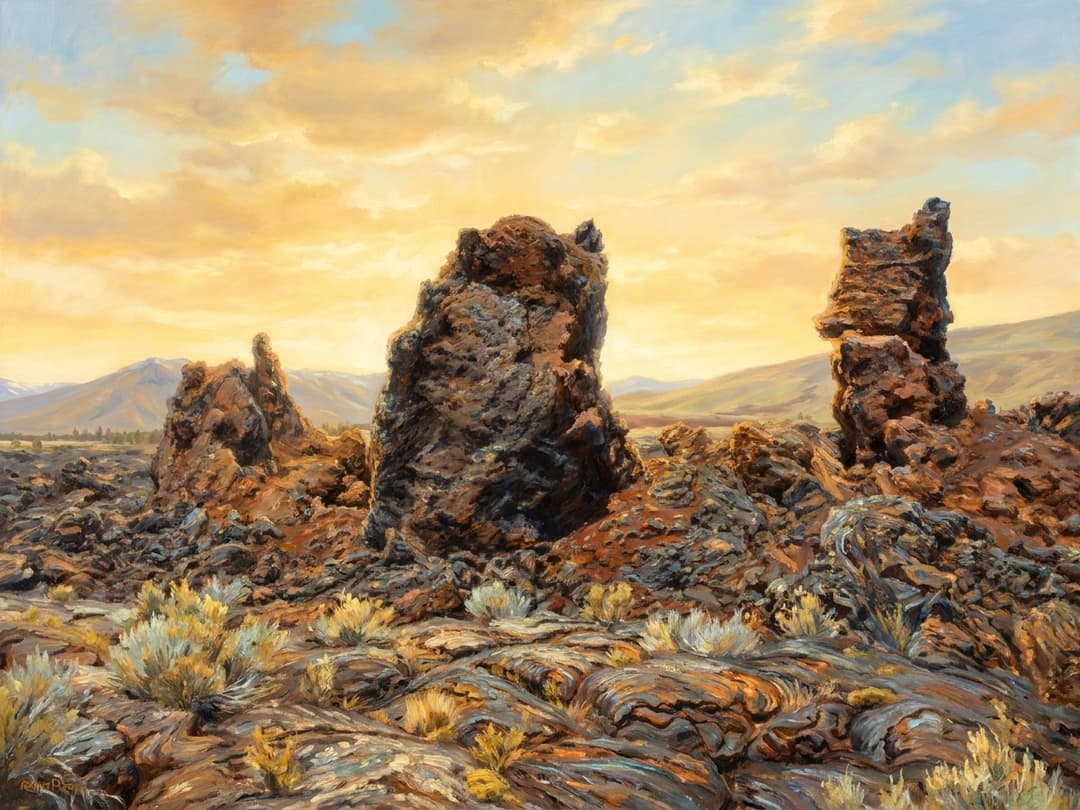
Visitors experience a dramatic open-air sanctuary defined by stark volcanic formations, ancient basalt plains, and quiet cave chambers. Walking along the trails offers profound reflection on the living relationship between geological forces and indigenous cultural memory.
Highlights
- Walking through the colossal subterranean archways of Indian Tunnel.
- Ascending Inferno Cone for sweeping vistas across the 52-mile Great Rift volcanic fissure.
- Viewing pristine kipukas preserving untouched native sagebrush-steppe ecology.
- Gazing into the dark volcanic night skies recognized as an International Dark Sky Park.
Things to Know
- Basalt terrain is abrasive and requires sturdy, closed-toe hiking boots.
- Free self-service cave permits are mandatory before entering any lava tube to protect bat habitats.
- All ancient stone hunting blinds and archaeological artifacts are strictly protected by federal law.
- Summer surface heat on dark basalt can exceed 150 degrees Fahrenheit, requiring ample water.
Location
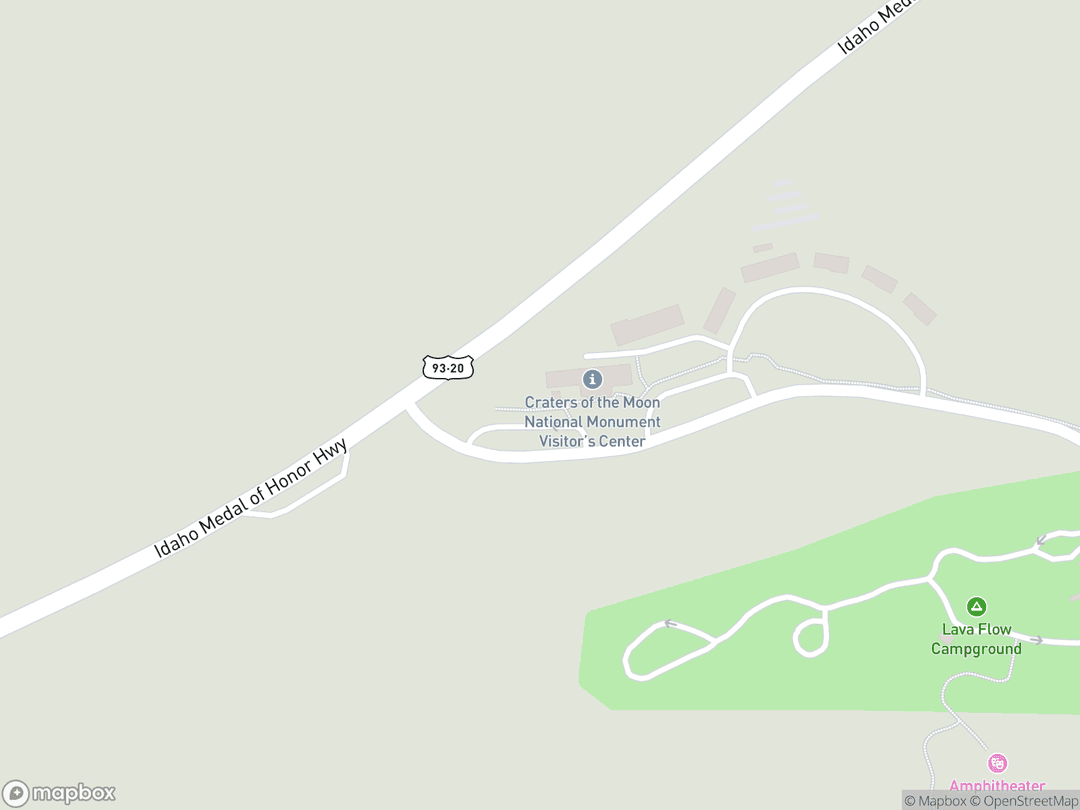
1266 Craters Loop Road, Arco, ID 83213
Hours: Open 24 hours daily year-round; Visitor Center open 8:30 AM to 4:30 PM daily.
Getting There: Located along US Highway 20/26/93, roughly 18 miles southwest of Arco and 24 miles northeast of Carey, Idaho.
Get DirectionsTips for Your Visit
Footwear and Hydration
Wear thick-soled hiking shoes to navigate sharp aa lava safely and carry at least two liters of water.
Cave Etiquette
Obtain a free cave permit at the visitor center and carry a reliable headlamp with extra batteries.
Stay on Marked Paths
Protect delicate cryptobiotic soil crusts and fragile cinder slopes by remaining strictly on designated routes.
About
The Craters of the Moon Sacred Lava Fields encompass an expansive volcanic landscape within the ancestral homelands of the Shoshone and Bannock peoples (Newenee). Shaped across millennia by deep subterranean fissures along the Great Rift, this open-air natural cathedral features vast basalt flows, towering cinder mounds, and subterranean lava tubes that served as sites of shelter, vision seeking, and spiritual encounter.
Rather than a barren wilderness, indigenous traditions understand this geomorphic terrain as an enduring spiritual sanctuary. Oral narratives recount the cosmic movements of the Great Serpent, whose immense coils squeezed the mountains until molten rock poured across the Snake River Plain, creating physical landmarks that remain central to tribal history and cultural continuity.
Today, the landscape operates both as an active ancestral sanctuary and a protected National Monument and Preserve. Tribal stewardship and federal partnerships continue to honor the geological, ecological, and sacred heritage of this monumental volcanic domain.
Gallery
Symbolic Elements
The temple's exterior features intricate carvings, each rich with spiritual meaning:

The Great Serpent
In Shoshone cosmogony, an agitated cosmic serpent coiled around the mountain, causing molten stone to burst forth.

Subterranean Ice Wells
Insulated lava tubes preserving perennial ice pools represent sacred thresholds between upper and underworld realms.

Sacred Stone Rings
Basalt rock blinds constructed along crater ridges embody cyclical time and enduring ancestral presence.

Pristine Kipukas
Islands of ancient soil isolated by surrounding lava flows symbolize uncorrupted botanical sanctuaries of wild medicinal plants.

Volcanic Fire
Elemental volcanic heat represents cosmic purification and the living vitality of Mother Earth.

Pahoehoe Basalt Coils
Smooth, ropy lava formations serve as the petrified physical evidence of the cosmic serpent's body.

Obsidian Blades
Volcanic glass deposits shaped into fine projectile points reflect technological mastery and sacred trade traditions.

Tree Molds
Hollow basalt columns formed around incinerated pine trunks symbolize impermanence, resilience, and memory.
Interesting Facts
Shoshone oral accounts describing the coiled Great Serpent accurately record real volcanic fissure eruptions witnessed over two millennia ago (Tier A).
Dozens of prehistoric stone hunting blinds constructed from basalt boulders remain preserved along high crater rims (Tier A).
NASA brought Apollo 14 astronauts here in 1969 to study volcanic terrains ahead of lunar expeditions (Tier A).
Perennial ice pools survive year-round inside subterranean lava tubes despite desert summer heat (Tier A).
Over five hundred isolated kipukas preserve some of the last virgin sagebrush-steppe ecosystems in the American West (Tier A).
Certain young lava flows exhibit an iridescent blue sheen caused by oxidized titanium-magnetite crystals (Tier B).
The Great Rift is the deepest known open volcanic fissure in the continental United States (Tier B).
Barren black cinders burst into vibrant magenta carpets of dwarf monkeyflowers every June (Tier B).
Designated an International Dark Sky Park in 2017, the monument offers pristine stargazing with minimal light pollution (Tier A).
Common Questions
Why is Craters of the Moon sacred to indigenous tribes?
It is the ancestral homeland of the Shoshone and Bannock peoples, holding physical records of the Great Serpent cosmogony.
Did native people live inside the lava fields?
They traversed the flows seasonally, using lava tubes for shelter and constructing stone blinds for hunting.
What is a kipuka?
A kipuka is an island of ancient soil and vegetation entirely surrounded by younger lava flows.
Are the lava fields permanently extinct?
The volcanic rift is considered dormant, with future basaltic eruptions geologically expected along the Great Rift.
Can visitors enter the lava tube caves?
Yes, visitors can enter designated caves after obtaining a free permit at the visitor center.
Featured Stories
The Coils of the Great Serpent
Time Immemorial
Shoshone oral tradition preserves the vivid memory of an ancient giant serpent struck by lightning along the mountain ridges. In its fury, the creature tightened its immense coils around the rock until the mountain erupted in fountains of liquid fire. Today, tribal elders trace the cooled, swirling pahoehoe basalt as the eternal physical presence of that cosmic encounter.
Source: Shoshone-Bannock Tribal Oral History & National Park Service Ethnography
Stone Blinds of the Ancient Hunters
c. 1200
Centuries before European contact, Northern Shoshone and Bannock hunters arranged basalt boulders into semi-circular hunting blinds along elevated crater lips. These stone parapets allowed hunters to blend seamlessly into the volcanic landscape, waiting for bighorn sheep and pronghorn channeled through natural lava gaps during seasonal migrations.
Source: Intermountain Archaeological Survey Records
Apollo Astronauts on Lunar Basalt
August 22, 1969
In August 1969, Apollo 14 astronauts Alan Shepard, Edgar Mitchell, Eugene Cernan, and Joe Engle walked across the jagged lava fields of Craters of the Moon to prepare for lunar landings. Geologists utilized the rift fissures, spatter vents, and basalt plains to train the crew in recognizing volcanic impact structures before they stepped onto the lunar surface.
Source: NASA Manned Spacecraft Center Geologic Training Records
Timeline
Paleo-Indian Habitation
Ancestral indigenous bands begin seasonal use of the Snake River Plain volcanic margins.
MilestoneGreat Rift Eruptive Period
Major fissure eruptions pour fresh basalt across central Idaho hunting corridors.
EventYoungest Volcanic Outpouring
Final fissure eruptions at North Crater give rise to Shoshone oral traditions of the cosmic serpent.
MilestoneStone Blind Construction
Hunters construct semicircular basalt walls along crater rims to intercept game.
MilestoneEquestrian Transhumance
Shoshone bands use pack horses along trails skirting the northern lava margins.
EventGoodale's Cutoff Established
Emigrant wagon trains begin utilizing northern lava corridors during westward migration.
EventFort Bridger Treaty
Treaty sets aside ancestral lands and precedes forced relocation to Fort Hall.
EventNational Monument Proclaimed
President Calvin Coolidge designates the volcanic field as a national monument.
DedicationApollo 14 Lunar Training
NASA astronauts explore the monument's lava tubes and craters to study volcanic geology.
MilestonePresidential Preserve Expansion
President Bill Clinton vastly expands the protected area tenfold through Proclamation 7373.
MilestoneNational Preserve Designation
Congress formally designates the expanded acreage as a National Preserve under joint federal management.
MilestoneCentennial of Protected Status
Centennial events highlight ongoing tribal cooperative stewardship and cultural preservation.
MilestoneHistory by Decade
10,000 BCE — Paleo-Indian Era
Following the retreat of Pleistocene glaciers, ancestral indigenous peoples inhabited the Snake River Plain. Semi-nomadic bands utilized the edge of cooling volcanic fields, hunting megafauna and establishing sacred paths across the emerging basalt landscape.
100 BCE — The Youngest Eruptions
The final major eruptive phase of the Great Rift occurred at North Crater and Sheep Trail Butte. Ancestral Shoshone witnessed fountains of fire and spreading pahoehoe flows, embedding these geological spectacles directly into enduring oral histories.
1700s — The Horse Era
The acquisition of the horse expanded the seasonal mobility of Shoshone and Bannock bands. Seasonal hunting parties navigated established trails across the lava fields while traveling between western camas prairies and eastern bison hunting grounds.
1860s — Emigrant Encroachment and Treaties
The creation of Goodale's Cutoff in 1862 brought emigrant wagon trains along the northern fringe of the volcanic fields. The Fort Bridger Treaty of 1868 subsequently led to forced tribal relocation to the Fort Hall Reservation, disrupting seasonal access while spiritual bonds persisted.
1920s — National Monument Establishment
Explorer Robert Limbert completed extensive expeditions across the volcanic field, publicizing the region's remarkable geology. On May 2, 1924, President Calvin Coolidge officially proclaimed Craters of the Moon National Monument to preserve its unusual geological formations.
2000s — Preserve Expansion and Collaborative Stewardship
President Bill Clinton signed Proclamation 7373 in November 2000, vastly expanding the protected monument area. Federal agencies expanded formal consultation with the Shoshone-Bannock Tribes, integrating traditional ecological knowledge into modern site interpretation.
Architecture & Facilities
The site functions as an open-air natural temple shaped by continental basaltic fissure volcanism along the Great Rift. Undulating pahoehoe terraces, jagged aa ridges, and towering spatter chimneys form monumental natural architecture recognized by indigenous traditions as living spirit ground.
Building Materials
Basaltic Pahoehoe
Smooth, ropy lava formations featuring subtle metallic blue and bronze iridescent crusts.
Aa Basalt
Dense, fractured scoria clinkers that formed natural defensive barriers and defined ancient trails.
Obsidian and Vitrophyre
Dark volcanic glass quarried by ancestral artisans for sharp projectile points and tools.
Pyroclastic Cinder Tuff
Charcoal-black volcanic gravel forming monumental cinder cones like Big Cinder Butte.
Interior Features
Indian Tunnel
A colossal lava tube chamber over eight hundred feet long illuminated by natural skylights.
Dewdrop Cave
A sheltered basalt cavern displaying delicate layered lava benches and breakdown blocks.
Boy Scout Cave
A frigid subterranean chamber that houses a perennial ice floor even through hot summers.
Beauty Cave
A deep lava tube terminus demonstrating pristine flow textures and smooth basalt ceilings.
Temple Grounds
Over seven hundred thousand acres of protected volcanic tableland featuring undisturbed sagebrush kipukas, ancient stone blinds, and fragile cinder ecosystems.
Additional Facilities
The Robert Limbert Visitor Center offers educational exhibits, tribal cultural panels, and backcountry permit facilities.
Religious Significance
To the Shoshone and Bannock peoples, the volcanic expanse is a living, conscious relative rather than an inanimate desert.
The landscape serves as a perpetual sanctuary for reflection, spiritual renewal, and honoring cosmic forces of earth renewal.
Sacred Ordinances
Vision Seeking and Fasting
Solitary contemplation undertaken within secluded lava caverns and remote cinder cones to seek spiritual direction.
Seasonal Harvesting
Ceremonial gathering of wild medicinal roots, sweetgrass, and minerals from protected kipukas.
Oral Remembrance Rites
The retelling of the Great Serpent cosmology to transmit sacred geography and ethical responsibility to younger generations.
Kinship with Volcanic Forces
Indigenous cosmologies view volcanic eruptions as physical expressions of earth transformation and spiritual purification.
The Sanctuary of the Kipukas
Surrounded by impassable fields of sharp aa lava, kipukas preserve native desert plants in their pristine ancestral state.
Sources & Research
Every fact on Temples.org is backed by verified Sources & Research. Each piece of information is rated by source tier and confidence level.
View All Sources (7)
| Field | Source | Tier | Retrieved |
|---|---|---|---|
| About & Historical Background | National Park Service (opens in a new tab) | A | 2026-02-18 |
| Indigenous Cultural Heritage & Treaties | Shoshone-Bannock Tribes (opens in a new tab) | A | 2026-02-18 |
| Timeline & Geologic Eruptions | National Park Service (opens in a new tab) | A | 2026-02-18 |
| Archaeological Records & Pioneer Trails | National Park Service History Electronic Library (opens in a new tab) | B | 2026-02-18 |
| Geographic Terrain & Rift Systems | PeakVisor Topographic Database (opens in a new tab) | B | 2026-02-18 |
| Cosmology & Symbolic Elements | Armchair Explorer Travel Guide (opens in a new tab) | C | 2026-02-18 |
| Visitor Insights & Regulations | South Idaho News Archive (opens in a new tab) | C | 2026-02-18 |